Digger_O'Dell
New member
Hi all,
Just to give a heads up, I discovered some problems while searching local Google maps looking for parks and other places to hunt. Apparently the Google app doesn't always show parks in green as they are normally shown, and sometimes even do not have park names or any other information when clicked on. This goes for Google Earth as well as I will show below:
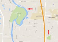
This is how Google maps normally shows parks, filled with green. This also applies to cemeteries and sometimes other select sites. As you zoom in, the name will appear. Zoomed too far out for the name, it is still green.

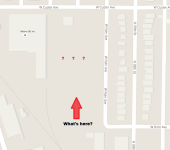
This is one of several locations I found recently. As you notice, there is a big blank spot. Not green, no information-even zoomed to maximum size.

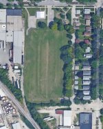
Here is the same location on Google Earth. Sort of looks like a park, doesn't it?

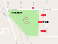
I was able to track down the name of the park and found this map clip on Facebook. But even this map is incorrect as it shows the industrial site on the West side as park also!

Doing a bit more looking, I now realize this is not an isolated case. I found 2 more parks just like this in a rather small geographical are and I am positive there must be a LOT more to be found. I expect that non-locals who don't know of the existence of these "hidden" locations won't make a detecting trip here. So I think if some of these locations can be found in your detecting area, they may be untapped sources of land!
Just to give a heads up, I discovered some problems while searching local Google maps looking for parks and other places to hunt. Apparently the Google app doesn't always show parks in green as they are normally shown, and sometimes even do not have park names or any other information when clicked on. This goes for Google Earth as well as I will show below:
This is how Google maps normally shows parks, filled with green. This also applies to cemeteries and sometimes other select sites. As you zoom in, the name will appear. Zoomed too far out for the name, it is still green.

This is one of several locations I found recently. As you notice, there is a big blank spot. Not green, no information-even zoomed to maximum size.

Here is the same location on Google Earth. Sort of looks like a park, doesn't it?

I was able to track down the name of the park and found this map clip on Facebook. But even this map is incorrect as it shows the industrial site on the West side as park also!

Doing a bit more looking, I now realize this is not an isolated case. I found 2 more parks just like this in a rather small geographical are and I am positive there must be a LOT more to be found. I expect that non-locals who don't know of the existence of these "hidden" locations won't make a detecting trip here. So I think if some of these locations can be found in your detecting area, they may be untapped sources of land!
Attachments
Last edited:
