You are using an out of date browser. It may not display this or other websites correctly.
You should upgrade or use an alternative browser.
You should upgrade or use an alternative browser.
topo map reference icon ??
- Thread starter Dimeman
- Start date
Digger_O'Dell
New member
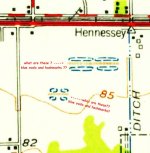
Because they are in blue, it means water. The lines being dotted means temporary of intermittent. By the looks of the map and the shape, I would think those are ditches or mad made runoff areas that may stay wet for long periods.
http://pubs.usgs.gov/gip/TopographicMapSymbols/topomapsymbols.pdf
http://pubs.usgs.gov/gip/TopographicMapSymbols/topomapsymbols.pdf
Full Metal Digger
Active member
My guess is wet areas during rainy time of the year.
