Pond built into a stream?

Trooper Bri

New member
Tuesday, Wednesday, and Saturday are my new days off. So with the mid-January thaw here, I had to get out today.
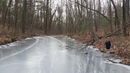
Spotted a man-made feature on Google Earth this summer, but saved it for a rainy day as it seemed more of a curiosity than anything else. Loaded up the gear and hiked in today for a peek. Found pretty much what I expected, a long frozen pond made from an existing stream.

Any idea what it would have been used for? The area north and east on the hill this is on is definitely level and big enough for fields, and there's existing fields 1/8 mile down the hill. No idea of depth, but guessing a few feet in the middle? Irrigation, cow/ox wash?
Detected around it for a couple hours but only managed a nice start to my 2015 shotgun shell count. Felt great to get out again though, even if I didn't find jack.
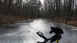
LongPond1.jpg

Ahead and to the right you can see the more level areas around this (facing north).
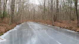
LongPond2.jpg

Facing south (downstream).
LongPond3.jpg
 
Brian it looks like is could of been part of a shallow canal system , are there any old mill sites with in a mile ??

also how did the machine handle in the cold ??
 
There's no end with rocks? Just dirt around it? Seems so from pics. I would presume irrigation. Out near where I grew up and there's a bottle dump there's also a pretty much round small pond with a little area of woods around it and then fields. What leado to it is some small marshy area that floods during the winter.

I thought also of another pond within a mile from that one where a stream was made into a pond. Big pipe at the downstream end and road on top. There is a field but maybe they planted crops before the 70's. Now it's a horse stable.

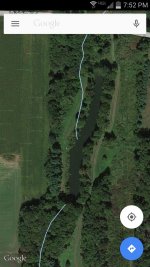
There are three of these in a near area to fields.
Screenshot_2015-01-21-19-52-50.jpg
 
Last edited:
Brian it looks like is could of been part of a shallow canal system , are there any old mill sites with in a mile ??

also how did the machine handle in the cold ??

No mill sites that I'm aware of Dan. Didn't see any stone piles or signs of structure in the area for damming. And it's not very big. I wonder if part of this was just a natural cut, and taken advantage of?
It wasn't really cold out today, but it's been behaving fine. Mineralization was more of an issue. That and lack of targets.
 
I wonder if part of this was just a natural cut, and taken advantage of?
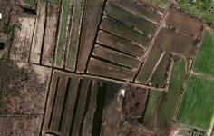
I'm sure there's a bit of taking advantage of the land shape. An island I went to had been used a for farming (and other stuff). Even tho it's surrounded by water, it's actually elevated quite a bit. Walking to the site through the wooded area there was definitely a spot where it was low lying and used to collect water. But another arial view of such. I know its a lot less wooded on each side as the spot you found. I found a bunch of these while looking in a town near where I been researching on a treasure legend, one place has a ridic amount of these.
Irrigation fields.jpg

Humm, perhaps for a logging operation to float logs down stream?
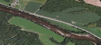
It was usually rivers that were used for the logging projects. About 6 hours from me, theres a place where I went with the ex's fam, which is actually a place I once brought the old old detector and found the cast irons and a glass bottle for Beyer aspirin and there's a cemetary not on a map with headstones dating to early 1800s. Their cabin was once an ice house. Anyway.. the nearby river has these small man made islands for the logging.

Logging river.jpg
 
Don't think it would be for logging. It's maybe 20ft wide and 150ft long.
Here's the pic from Google Earth that easily caught my eye. Nothing else of interest in the area. Dunno if a trip to the library would reveal anything.

Googdam.jpg
 
UFO Crash site?

anyways, nice find on the map and it's nice to get out this time of year. Lot of frost in the ground in my area so I'll be staying inside again this weekend.
 

Forum statistics

Threads
23,579
Messages
238,134
Members
3,788
Latest member
Skeyxc
Back
Top